Read Flying Off Everest Online
Authors: Dave Costello
Flying Off Everest (27 page)
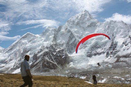
Nima Wang Chu (left) watches as the team’s cameraman, Shri Hari Shresthra (center), films Babu’s inaugural flight with the new wing at Kala Patthar.
BALKRISHNA BASEL
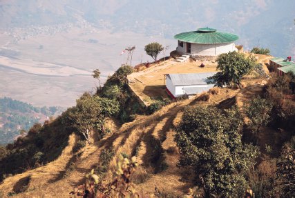
The Sirkot headquarters of Babu and Lakpa’s new paragliding company, Flying Himalayan.
DAVE COSTELLO

Lakpa Tsheri Sherpa on his Royal Enfield motorcycle in Pokhara.
DAVE COSTELLO
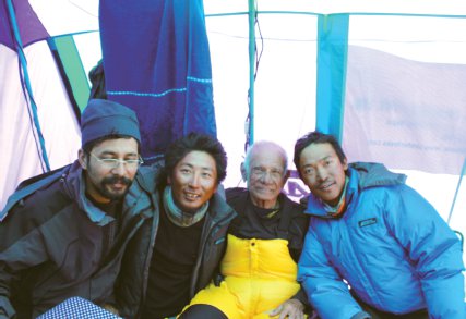
From left to right: Shri Hari Shresthra, Lakpa Tsheri Sherpa, Shailendra Kumar Upadhyay, and Sano Babu Sunuwar.
PHU DORJI SHERPA
*
Under the current Nepali system of government, individual villages are known as “wards.” They typically are numbered one through nine and grouped together with other nearby communities into slightly larger Village Development Committees (VDCs). So Babu’s family lives in Ward 6 of the Rampur VDC.
*
There is now a single-lane dirt road running along the length of most of the Sun Kosi, as well as a small suspension footbridge connecting the trail to Rampur-6 to the new road.
*
In kayaking or rafting, whitewater rapids are typically divided into six classes, each denoted with a Roman numeral. Class I is moving flat water with a few small waves; it is straightforward to navigate in a boat. Class II is relatively small rapids; waves up to three feet; and wide, clear channels that are still somewhat easy to navigate. Class III is rapids with high, irregular waves and narrow routes through hazards. It often requires complex maneuvering to navigate in a boat. Class IV is difficult rapids with restricted passages, requiring precise maneuvering in turbulent water. Conditions often make rescue difficult. Class V is extremely difficult, long, and violent rapids. Rescue conditions are exceedingly difficult, and there is a significant hazard to life in the event of a mishap. Class VI is typically considered unrunnable.
*
According to Nepal’s 2001 National Census. That number has since jumped to 65.9 percent, according to the 2011 National Census.
*
The offices of Blue Sky Paragliding moved in April 2013 to another location in the Lakeside area, farther south. The large picture of Hanuman is gone, but the yeti still stands watch near the entrance.
*
The term Sherpa is actually the anglicized mispronunciation of the ethnic designation “Shar-wa” (literally “person from the east”). Sharwa among themselves have approximately twenty surnames, or clans (historically originating in the Tibetan province of Kham), one of which is, confusingly enough, Sharwa.
†
Lhakpa can also be spelled without the h when used as a given name, which is how Lakpa Tsheri Sherpa chooses to spell his name, and thus is how he is referred to here.
‡
“Tsheri” is the Tibetan spelling. It would be “Chirring” in Nepali.
§
The Himalayan Trust is a nonprofit organization that was started by Sir Edmund Hillary. It continues to be involved in helping Sherpas better their communities through projects they themselves support but request assistance for.
*
Dialects between Sherpa communities vary as much as 30 percent—not enough to officially count as separate languages, but enough to be thoroughly confusing.
†
Potatoes, although currently the main cash crop in the Sherpa economy, are a fairly recent phenomenon in Nepal—introduced first in the nineteenth century by British travelers. Traditionally, Sherpa agriculture relied on maize, barley, buckwheat, and vegetables.
*
Two years earlier, Giorgio had stood on top of Everest and placed a Red Sox cap on the summit, along with an American flag for the same purpose, at a lama’s suggestion. He reportedly also burned a Yankees cap with kerosene when he returned to Base Camp. The Red Sox didn’t win the World Series that year, but Giorgio’s 2003 gesture must have done the trick: Boston claimed the World Series title in 2004, breaking its eighty-six year drought.
*
Flooding on the Dudh Kosi and other rivers in the Himalaya is intermittently caused by a glacial lake outburst flood (GLOF), in which a glacial lake contained by continually shifting ice and moraine suddenly bursts, releasing a staggering amount of water in a matter of minutes. One on the Dudh Kosi in August 1985 had a flow of 11,000 cubic meters per second—seventeen times the average flow for that time of year. A 30-foot-high wall of water, mud, and debris swept away bridges and houses and in places even gouged out an entirely new river channel.
*
The highest peaks on each of the seven continents, also known as the Seven Summits, are Everest, 29,035 feet (Asia); Aconcagua, 22,834 feet (South America); McKinley (aka. Denali), 20,320 feet (North America); Kilimanjaro, 19,340 feet (Africa); Elbrus, 18,510 feet (Europe); Vinson Massif, 16,067 feet (Antarctica); and Kosciuszko, 7,310 feet (Australia). Kosciuszko’s status as highest point in Australia is up for some debate. Many have argued that the highest point in Oceania, the group of lands that includes Australia and is technically part of the same continent, is not Kosciuszko but rather the 16,535-foot Carstensz Pyramid in the Indonesian province of Irian Barat.
*
A SPOT Messenger is a handheld GPS unit that automatically relays the device’s coordinates via e-mail or text message to anyone signed up to “follow” it. It also provides a link to the device’s location on Google Maps, and it is capable of sending a distress signal to the GEOS Rescue Coordination Center. In Babu and Lakpa’s case, the device would allow Phinney to track their progress from San Francisco.
*
Gondwana, also called Gondwanaland, was an ancient supercontinent that incorporated present-day South America, Africa, Arabia, Madagascar, India, Australia, and Antarctica. It was fully assembled some 600 million years ago by Late Precambrian time, and the first stage of its breakup began in the Early Jurassic period, about 180 million years ago.
†
The Tethys Sea was a tropical body of salt water that separated the supercontinent of Laurasia in the north from Gondwana in the south during much of the Mesozoic Era (251 to 65.5 million years ago).
*
Although Mount Everest currently holds the record for being the world’s highest mountain at 29,035 feet, the ninth-highest mountain, Nanga Parbat (26,660 feet), at the far western end of the Himalaya, is the fastest rising and may one day stand taller.
*
The current height of Mount Everest, calculated with lasers and Doppler satellite transmissions, is generally agreed to be 29,035 feet.
*
Today, the official Nepali designation for Mt. Everest is Sagarmatha, “goddess of the sky.” The name was rarely, if ever, used before 1960. At that time there was a border dispute with China, and Nepal’s prime minister, B. P. Koirala, believed it would help Nepal assert its claim to the southern side of Everest if there were a widely recognized Nepali name for it. He chose Sagarmatha at the suggestion of his advisors, and the national park that encompasses the Nepali side of the mountain still bears the name.
†
Founded in 1972, the Mountain Institute is a nonprofit organization headquartered in Washington, DC, with offices in West Virginia, Nepal, and Peru (home to the world’s oldest, tallest, and longest mountain ranges, respectively). It is committed to economic development in the mountains, conservation of mountain environments, and support for mountain cultures.
*
There’s some debate over which American expedition, exactly, reached the North Pole first. Robert E. Peary sent word from Indian Harbour, Labrador, in April 1909, that he and his companions had reached the pole first. The news was printed on the front page of the
New York Times
on September 7. A week prior, however, the
New York Herald
had printed a front-page headline of its own, stating that Dr. Frederick A. Cook, an American explorer who, after having spent more than a year wandering in the Arctic, was given up for dead, had returned and claimed to have reached the pole in April 1908—a full year before Peary. The argument is still technically up for debate. Neither claim has been either proved or disproved, even after a full reexamination of both expeditions’ records, which was commissioned by the National Geographic Society in 1988.
*
The four mountains whose summits are even farther away from earth’s center than Everest (3,965.8 miles from the planet’s core), are Tanzania’s 19,341-foot Kilimanjaro (3,966 miles), Ecuador’s 19,347-foot Cotopaxi (3,966.9 miles), Peru’s 22,139-foot Huascaran (3,967.1 miles), and Ecuador’s 20,565-foot Chimborazo (also 3,967.1 miles, but about 82 feet farther out than Huascaran). All numbers are approximate.
*
In 1999 American climber Conrad Anker found Mallory’s body on a ledge at 27,000 feet. Evidence suggests that Mallory, at least, didn’t make it to the summit before perishing, but no one will ever really know for sure. Andrew Irvine’s body was never found.
*
Hillary and Norgay agreed to not tell anyone who had made it to the top of Everest first. Norgay said, “It is a foolish question. The answer means nothing… Mountaineers understand that there is no sense to such a question; that when two men are on the same rope they are together, and that is all there is to it.” Once they arrived back in Kathmandu, they both signed a public statement stating that they had “reached the summit almost together.” Later, after much harassment, Norgay acknowledged that Hillary “stepped on top first. And I stepped up after him.”
*
A
chorten
is a religious monument, typically made of stone and often containing sacred relics; it is also called a
stupa.
†
Mani
stones are small, flat rocks that are hand-carved with Sanskrit symbols denoting the Tibetan Buddhist invocation
Om mani padme hum.
They are piled along the middle of trails to form long, low
mani
walls. Buddhist protocol dictates that travelers always pass
mani
walls on the left.
*
Cwm (pronounced “coom”) is a Welsh word for a bowl-shaped valley. It was conferred on the upper reaches of the Khumbu Glacier by the 1921 English reconnaissance expedition, the first Westerners to see it.
*
The human body can actually “adapt” to functioning at altitude, where there are significantly less oxygen molecules in each breath, through a process called acclimatization. The act of inhaling less oxygen naturally stimulates an increase in breathing. The kidneys then begin to unload bicarbonate to compensate, and the body releases more of the hormone erythropoietin to stimulate red blood cell production, which enables the body to literally carry more oxygen. This adaptation can take many days, although up to 80% occurs in the first forty-eight to seventy-two hours.
*
A bergschrund is a deep crevasse that delineates a glacier’s upper terminus, marking the point where the ice slides away from the steeper wall immediately above, leaving a gap between the glacier and rock. Whereas a crevasse can be only a few hundred feet deep at most, there is no limit to how deep a bergschrund can go.
†
Fifteen aluminum ladders were used in 2011 to negotiate the icefall, fewer than normal.
*
In 2010 a thirteen-year-old boy from Big Bear, California, named Jordan Romero became the youngest person to make the summit, ousting the previous record holder, Nepal’s Temba Sheri, who climbed to the top at the age of sixteen. In 2013 eighty-year-old Yuichiro Miura claimed the title for the oldest person to have summited, ousting the previous record holder, who was seventy-six. Miura had summited twice before, each time earning himself the title of oldest person to summit Everest.
*
According to the SPOT website, Everest itself lies within an area of “reduced or no coverage available within a 20 minute period.” It’s impossible to say for certain what, exactly, caused Babu and Lakpa’s device to malfunction almost immediately after takeoff, since numerous factors can scramble a GPS signal. However, considering that the handheld unit they were using was trying to communicate with four separate satellites orbiting the earth at a height of about 11,500 miles, traveling at approximately 9,000 miles per hour in different directions, while Babu and Lakpa were simultaneously flying over Everest, it would have been more surprising if it had worked.
*
Paramotor
is a generic name for a motorized paraglider, typically propelled by a large fan mounted to the frame in which the pilot sits.
*
Babu and Lakpa never actually applied for a world record attempt through the Fédération Aéronautique Internationale (FAI), the Swiss governing body that manages all paragliding and hang gliding record keeping. Therefore they didn’t receive an official “world record” for their flight over Everest, which, indeed, went a bit higher than both Jean-Marc Boivin’s and Claire and Zebulon Roche’s. Interestingly, the FAI doesn’t even recognize any free flight world altitude record. According to FAI Record Officer Christine Rousson, “Only records listed in the Sporting Code, Section 7 are permitted.” And the record for who goes the highest while strapped to a paraglider isn’t in that section. It isn’t in any section. So Boivin and the Roches never, technically, held that record either. No one has.
*
The Namgyal Monastery Audio Visual Archive Center’s sole purpose is recording the Dalai Lama’s teachings through both audio and video. It was founded in 1980 and originally operated by the Meridian Trust, a UK-based nonprofit that looks to preserve Tibet’s cultural heritage. The program was taken over by the Namgyal Monastery itself after the trust suddenly took all of its camera equipment back in 1989. Now filmmakers from around the world volunteer their time, helping the monks themselves record His Holiness’s teachings.
*
The “River of Gold” gets its name either from the small flecks of gold that are sometimes panned out of its gravel beds or from the orange-brown color of its waters during the monsoon, when the entire length of the Sun Kosi runs thick and dark with alluvial silt. Likely, the name originated with a little bit of help from both of these attributes.
*
Since the right and left side of a river can switch depending on what direction you’re facing, paddlers typically use the terms “river right” and “river left” to describe directions in relation to facing downstream. This is similar to how actors use the directions “stage right” and “stage left.”
*
It’s worth noting that even if Babu, Lakpa, and Krishna had brought maps of the Ganges with them, it wouldn’t have done them much good. Like the Sun Kosi Fan, the Ganges shifts its course radically through the Bihar almost every year, often cutting completely new channels miles from where it had previously flowed. Even more problematically, the government of India does not allow anyone, Indian or foreign, to buy topographic maps of any region less than 62 miles from the country’s borders, which is exactly where the Ganges flows, so such useless maps don’t even exist.